Digital Marketing
The Overlooked Power of Paid Search for Manufacturers
Read Storyby RefractROI

Google Maps is one of the most useful and widely used programs today. And what has set it apart from its competitors? Its Street View feature.
This year, Google is partnering with the National Park Service, which is celebrating its 100th birthday. Google is said to bring more of its parks into Google Street View, a total of 40 national parks that include Santa Cruz Channel Island and Montezuma Castle National Monument.
Earlier this year, Google Street View also received much acclaim for its civic benefits, which center on guiding economic development through optimized data gathering.
Google Street View isn’t only convenient for a user looking for an address or a tourist wanting to get a glimpse of famous landmarks, but it is driving growth and development in larger scales.
Street View, which offers an interactive view of any street, is definitely one for the books. With data gathering as its primary purpose, it enables Google to enhance accuracy of Google maps, mobile location, and navigation. The fun that comes with the feature is merely a side effect.
What’s more, no one else has it. But it looks like Apple is about to follow suit.
Apple may be working on its own version of Google Street View, if recent announcements are anything to go by. Apple’s current map service Apple Maps is quickly gaining popularity over Google Maps among iPhone users and has a range of features, like public transportation, that can easily rival Google’s.
In a section in Apple Maps talking about “Apple Maps vehicles”, the company says that it “will blur faces and license plates on collected images prior to publication.” Google Street View also blurs out people’s faces within the vicinity, possibly hinting Apple could be a launching similar program.
The documentation goes on to list cities around the world where its cars will be driving, including the US and some parts in Europe.
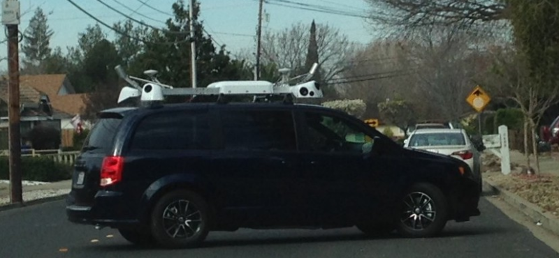
Speculations about Apple’s plans to recreate their own Google Street View started around February last year, when vans linked with Apple were seen driving around in New York and the San Francisco Bay area. The vans were equipped with cameras, the same thing Google’s vans had when they sent cars around the world to gather data for Street View.
According to the “Driving Locations” schedule for Apple’s cars, the company will take photos of New York, California, Paris and London between January 4 and February 14.
In contrast to rumors, it’s also possible Apple is just working on its flyover feature, which is said to offer 3D versions of famous buildings, like the Empire State Building in New York and Parliament in London.
Another interesting theory is that the vans were sent out for something else entirely: autonomous, self-driving vehicles. If the vans were indeed from Apple, which the company never confirmed, then this project could be related to Steve Job’s unrealized dream of designing a car.
As of now, regardless of its improvements, Apple Maps still has a way to go before completely topping Google Maps in non-Apple users. If the company really is creating an “Apple Maps Street View”, maybe it’ll help Apple Maps gain some competitive foothold and so to speak, put itself “on the map.”
To know about the latest in digital and mobile news, stay connected with RefractROI-partners, the leading SEO company in Denver.
Hey there, anything we can assist with?